Philippines Typhoon Haima 2016
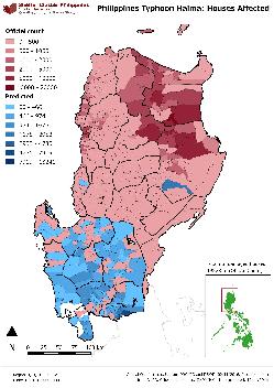
Housing damage map: official count + predicted damage for Regions I, II, III & CAR
Some notes and assumptions:
Predictive algorithm
This calculation is based upon a number of variables and geographic traits at the municipal level. The underlying data that it uses includes:
(1) Administrative boundaries (P_Codes) - Philippines Government; Published by GADM and UN OCHA (HDX)
(2) Census 2015 (population) - Philippine Statistics Authority; received from UN OCHA (HDX)
(3) Avg. wind speed (km/h) - University College London
(4) Typhoon path - University College London, distance from path
(5) Houses damaged - NDRRMC
(6) Rainfall - GPM
(7) Poverty - Pantawid pamilyang pilipino program (aggregated)
Also underlying this analysis is a comparative study of these same traits compared against previous typhoon events in Philippines including Typhoons Pablo and Yolanda. This predictive model should be seen as indicative of a potential scale of damage in these affected regions.
Damage data is the addition of totally destroyed figures added to partially damaged figures. The predictive model is not at the point where these two sub-classes of damage can be inferred.
If there is interest in assisting to further develop the machine learning behind the predictive modelling, we would welcome any attempt by the cluster and its partners to collect more accurate damage data from gap areas.